- HOME >
- Satellite Projects >
- DAICHI-4(ALOS-4)

Monitoring the Earth with "ALOS-4"
ALOS-4 is an Earth observation satellite using its on-board Phased Array type L-band Synthetic Aperture Radar. L-band radar technology has been continuously developed by Japan. With the implementation of new technologies, it further improves the performance of the previous ALOS-2, accomplishing the world's highest level of resolution and observation coverage (wide area observation).
ALOS-4 Appearance and On-board Instruments

①Phased Array type L-band Synthetic Aperture Radar-3 (PALSAR-3)
Sensor to obtain information by transmitting microwave to the Earth's surface and receiving it reflected from the surface.
②Solar array paddle
Instrument to convert solar light into electric power in orbit and supply the satellite with this power.
③Direct transmission antenna
Antenna to transmit image data acquired by the satellite directly to the ground stations.
④Automatic Identification System (AIS) Antenna (SPAISE3: SPace based AIS Experiment 3)
Antenna to receive signals from vessels. The signal contains information such as vessel type and position.
⑤Laser-communication terminal
Instrument to connect optical communication to LUCAS: Laser Utilizing Communication System
Solar array paddle captured by the monitor camera onboard ALOS-4
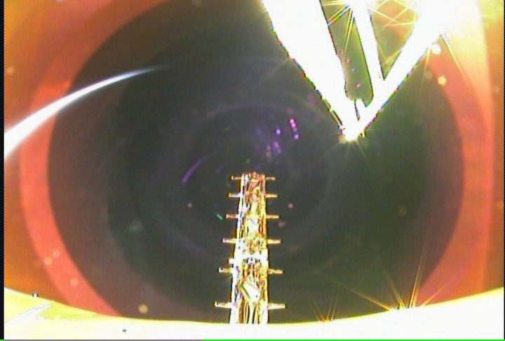
SPAISE3 antenna after the deployment captured by the monitor camera onboard ALOS-4
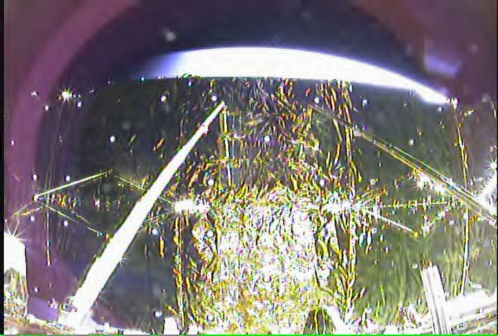
PALSAR-3 after antenna package deployment captured by the monitor camera onboard ALOS-4
The following website allows you to check the present location of ALOS-4.

The mission of ALOS-4 is to contribute to various areas such as crustal deformation, disaster situations, environmental change, and ocean, by regularly observing the entire Earth.

How does ALOS-4 observe the Earth?
ALOS-4 Feature Part 1
ALOS-4 uses a technology called Synthetic Aperture Radar (SAR) to observe the Earth.

SAR transmits microwaves to the Earth and obtains information about the surface conditions from the reflected microwaves.
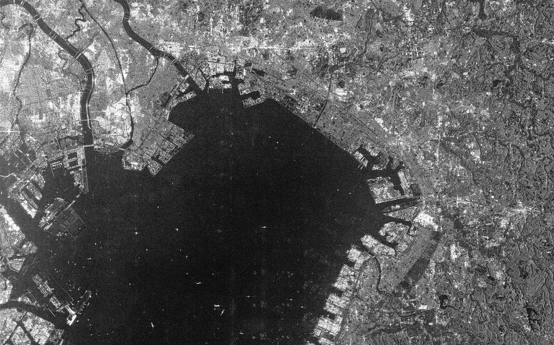
SAR image
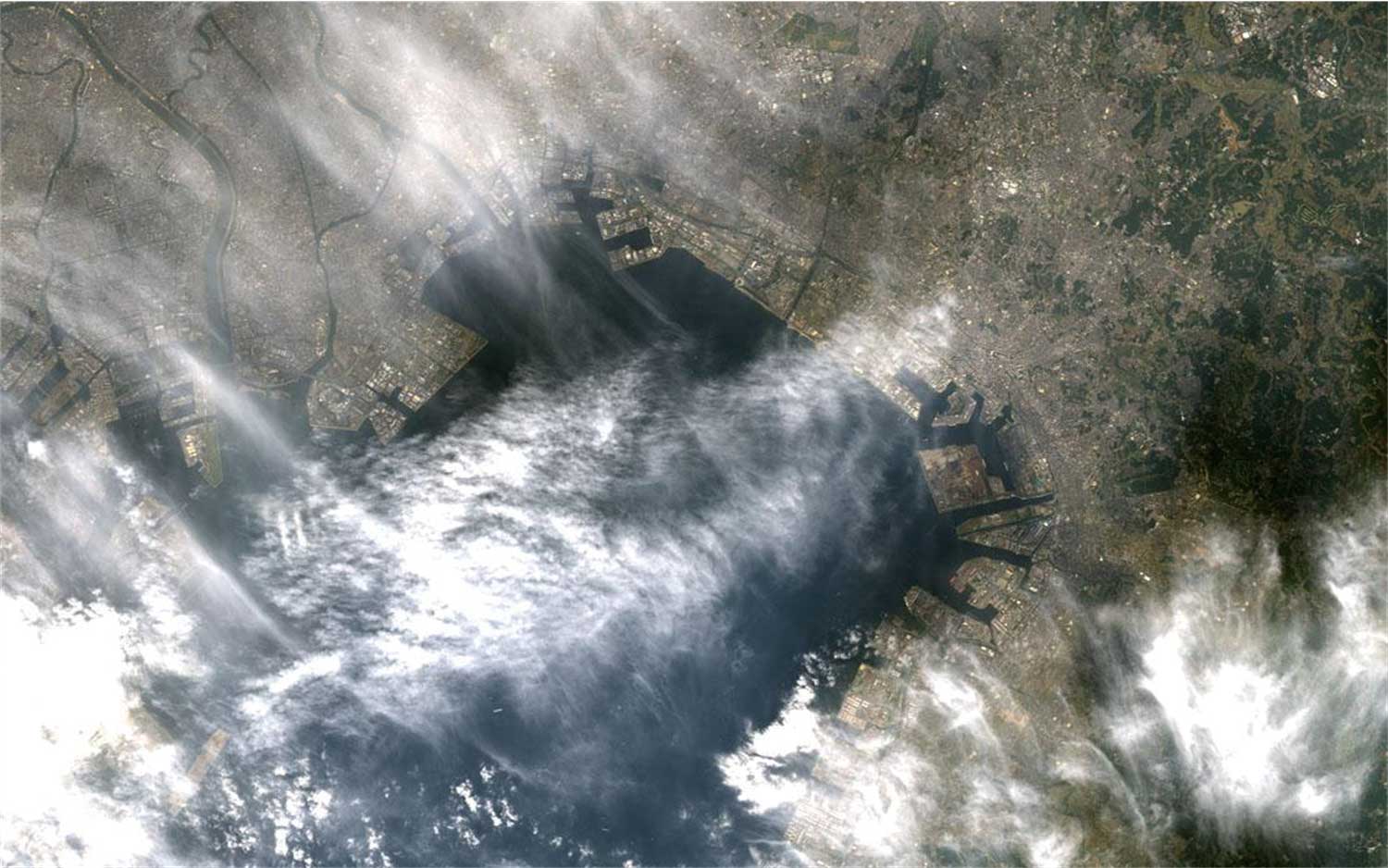
Optical sensor image
(Invisible under clouds or at night)
SAR observes using its own transmitted microwaves. This means it doesn’t need sunlight and can even observe at night. In addition, since the microwaves transmitted by SAR can penetrate clouds and rainfall, it is possible to observe regardless of the weather!

ALOS-4 Feature Part 2
L-band microwaves are used.
There are different types of microwaves, and compared to the X-band (3 cm wavelength) and the C-band (6 cm wavelength) commonly used in other SAR satellites, the L-band (24 cm wavelength) can better penetrate vegetation and has high coherence. This makes it possible to detect ground conditions and changes stably even in Japan, where about two-thirds of the country is covered by forest.

Previous ALOS Series
ALOS-4 is an immense leap from the previous ALOS series!

Technology
POINT 1: Significantly increased coverage and frequency of observations!
“ALOS-2” has been used for quickly grasping disaster situations, but wider observation coverage and higher temporal frequency are required for early detection of anomalies and preparation for major disasters.
ALOS-4, equipped with "Phase Array type L-band Synthetic Aperture Radar-3 (PALSAR-3)", had significantly improved its capabilities, expanding the observation width from 50 km to 200 km and increasing the observations frequencies from about 4 times a year to about 20 times a year.
DBF-SAR (Digital Beam Forming)
Received microwaves are digitally processed at high speed, enabling simultaneous observations in up to 4 directions.


POINT 2: State-of-the-art space-based AIS (Automatic Identification System) for ship
AIS is a system installed as mandatory equipment on ships of 300 tons or more, which transmits and receives information such as the ship type and location using radio waves. Currently, there are challenges because, in areas with a high density of ships, the radio waves overlap and cannot be received by the satellite-based AIS. ALOS-4 is equipped with a newly developed AIS (SPAISE3) to solve this issue, and it will contribute to the safe navigation of vessels by collaborating with SAR observation.

POINT 3: Major upgrade in communication/data transmission capacity with the satellite! (Data relay)
By communication with "LUCAS" – the Laser Utilizing Communication System, in geostationary orbit about 36,000 km from Earth, a significant increase in communication time with ALOS-4 is realized. This enables a quicker response to emergency observation requests during disasters, and more data can be transmitted to the ground than before.


Observation data are transmitted to the ground station in Ka-band (3.6 Gbps), which is 4.5 times faster than X-band (0.8 Gbps) of ALOS-2, using a newly developed transmission system. It is much faster compared to a typical home internet connection (less than 1 Gbps). New ground station facilities at the JAXA Tsukuba Space Center (in Ibaraki) and the Earth Observation Center (in Saitama) are used.

Mission

Watching every tiny change for a sustainable future.
Crustal deformation
Technology to Map Ground Movement - Interferometric SAR.
ALOS-4 can measure how much the ground has moved by comparing the phase (position) of the microwaves between two observations made at different times. This technology, called "Interferometric SAR (InSAR)", is highly valuable in monitoring natural disasters, as well as crustal and ground deformation.

Detecting Signs of Volcanic Activity for Precautionary Safety Measures
With the help of InSAR, it is possible to detect minute changes due to volcanic activities. During the June 2015 eruption at Mt. Hakone, Kanagawa Prefecture, the ground uplift was captured prior to the eruption, which proved useful for pre-evacuation activities. ALOS-4 has increased its observations frequency, and the monitoring system is expected to be further improved.

Monitoring Crustal and Ground Deformation throughout Japan
By statistically processing many data observed at high frequency by ALOS-4, compared to InSAR with a single processing, more detailed ground movements (order of a few cm to mm) can be detected. In collaboration with the Geospatial Information Authority of Japan, which has advanced InSAR analysis technology, JAXA is planning to monitor the entire country of Japan.

Disaster Management
In recent years, as natural disasters have intensified nationwide, more comprehensive and rapid disaster assessment using ALOS-4 is expected. JAXA is collaborating with various organizations, including the government and local authorities, to contribute to minimizing damage and improving the effectiveness of disaster response through rapid information sharing by "Emergency Observations" and “BOUSAI INTERFACE” immediately after a disaster.

Quick Identification of Flooded Areas due to Heavy Rain
SAR, which can detect ground conditions even at night or in bad weather conditions, is beneficial for quickly assessing damage caused by heavy rainfall. Efforts are also being made to automatically detect flooded areas from observation images, which will be provided for recovery activities and damage investigations by disaster prevention agencies and local governments.

Understand Distribution of Extensive Damage from Earthquakes
Major earthquakes cause widespread damage. ALOS-4 Phased Array type L-band Synthetic Aperture Radar (PALSAR-3) has three observation modes: Spotlight, Stripmap (High resolution), ScanSAR (Wide-area observation). In ScanSAR mode (Wide-area observation), a single observation can cover an area of 700 km in the east-west direction (one of the widest observation widths among SAR satellites in the world). This is particularly useful for assessing damage, such as the destruction of roads and buildings. Additionally, information on crustal deformation by InSAR is utilized to estimate fault movements and deformations.

JAXA's efforts in disaster cases
Forestry and Agriculture
Understanding Global Forest Change
L-band microwaves used by ALOS-4 are effective in determining the size/volume of trees in forests, which is useful for understanding global forest distribution and change, and for estimating carbon storage (biomass) in forests. This technology is expected to contribute to tropical deforestation and climate change issues.

Global mosaic map based on SAR Imagery

Global forest distribution estimation

Making Agriculture More Convenient with SAR and AI
Knowing where and how much crops are being grown is critical for shaping national agricultural policies and ensuring food security. ALOS-4 is also used to understand the area of rice paddy field planted, and its contribution to improving agricultural statistics in several countries, mainly in Southeast Asia, is expected.

AI and satellite data-based map of paddy rice cropping in Southeast Asia
Ocean
Unraveling the Structure of Typhoons
SAR is gaining high expectations as a means of examining the sea surface wind speed under typhoons with high resolution. ALOS-4 can capture the entire typhoon in a timely manner, with its observation range of several hundred kilometers, and its application to typhoon track prediction is expected.

Specifications
| Items | Specifications |
| Mission instrument |
Phased Array type L-band Synthetic Aperture Radar-3 (PALSAR-3)
--Stripmap mode (High resolution)
--ScanSAR mode (Wide-area observation)
SPace based AIS Experiment 3 (SPAISE3) |
| Size | 10.0 m x 20.0 m x 6.4 m (Solar array paddle and all antennas deployed included) |
| Mass | Approximately 3 tons |
| Design life | 7 years |
| Operational orbit | Sun-synchronous orbit/Altitude 628 km |
| Launch date | July 1, 2024 |
| Launch rocket | H3 Launch Vehicle, No.3 |
| Prime contractor | Mitsubishi Electric Corporation |
Spotlight mode
Stripmap mode
ScanSAR mode
Related Information
ALOS-4 Development system

How is a satellite born?
Overview of Tests
(1) Vibration Test
Aim: Optical inter-satellite communication has the property that, compared to radio wave communication, the antenna direction control is more easily affected by vibrations (known as disturbances) generated by the satellite’s on-board instruments. In order to confirm the disturbances, ALOS-4 was suspended, and each instrument was operated to measure the acceleration in response to accelerometer sensors attached to each part of the satellite.
Vibration Test
(2) Thermal Vacuum Test
Aim: The test was conducted in a space chamber to create a vacuum and simulate the harsh thermal environment encountered in orbit, ensuring to prove that ALOS-4 operates normally and meets all functional and performance requirements.
Space chamber: A vacuum container used to verify the environmental durability of satellites under the vacuum and heat of space
Thermal Vacuum Test
(3) PAF Separation Impact Test
Aim: After satellite launch, significant shock impacts occur during separation (when the separation mechanism is activated) from the rocket. The test was conducted to ensure that the impact would not cause any damage, indentation, etc. to the Payload Attach Fitting (PAF) connecting ALOS-4 and H3 Launch Vehicle and that ALOS-4 would not malfunction or fail.
Satellite separation (CG movie)
Related Sites
- ALOS-4(DAICHI-4) site of Earth Observation Research Center
- Satellite tracking operations: Space Tracking and Communications Center
- Fan! Fan! JAXA! ALOS-4 X H3 site (Japanese Only)
Data Use
- Access JAXA Satellite Data, including the “ALOS” series
- For users who wish to use the information and services from satellite observations
※ Please search using the keyword “ALOS”.
Pamphlets
- Download a pamphlet of Advanced Land Observing Satellite-4 ALOS-4 (DAICHI-4)