- HOME >
- Satellite Projects >
- IBUKI GW (GOSAT-GW)

Mission
Earth's Water and Greenhouse Gases Observation from Space
In recent years, disasters caused by extreme weather have become more severe, and understanding climate change, which is believed to be the cause, is essential to predict the impact on society and develop countermeasures. To contribute to this effort, JAXA has been developing the Global Observing SATellite for Greenhouse gases and Water cycle (GOSAT-GW*1).

A Hybrid Satellite Combining the AMSR and GOSAT Series
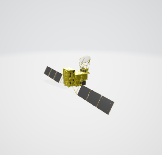
GOSAT-GW is a hybrid satellite that carries both the Advanced Microwave Scanning Radiometer 3 (AMSR3), which observes water cycle such as sea surface temperature, and the Total Anthropogenic and Natural emissions mapping SpectrOmeter-3 (TANSO-3), which observes greenhouse gases. These sensors are the AMSR series and the GOSAT series respectively, enabling GOSAT-GW to simultaneously observe water and greenhouse gases.
The mission of GOSAT-GW is a developmental continuation of the water cycle variation observation mission of "SHIZUKU" (GCOM-W*2), which was launched in 2012, and the greenhouse gases observation missions of "IBUKI" (GOSAT*3), which was launched in 2009, and "IBUKI-2" (GOSAT-2*3), which was launched in 2018.
GOSAT-GW is equipped with two successors, the Advanced Microwave Scanning Radiometer 3 (AMSR3), and the Total Anthropogenic and Natural emissions mapping SpectrOmeter-3 (TANSO-3), which was developed by JAXA under a contract with the Ministry of the Environment. Mitsubishi Electric Corporation is primarily responsible for the development of the satellite and its onboard sensors.
*1 The Global Observing SATellite for Greenhouse gases and Water cycle
*2 The Global Change Observation Mission – Water
*3 The Greenhouse gases Observing SATellites
The mission logo symbolically represents icons of the natural environment and the water cycle, providing an at-a-glance image of the areas where GOSAT-GW contributes.
GOSAT-GW and its onboard sensors

①AMSR3
(Advanced Microwave Scanning Radiometer 3)
The Advanced Microwave Scanning Radiometer 3 (AMSR3) observes weak microwaves naturally emitted from the land and ocean surfaces and in the atmosphere.
Number of frequency bands of AMSR3 is increased compared to that of AMSR2 to enable observations of snowfall and water vapor in the upper atmosphere.
②TANSO-3
(Total Anthropogenic and Natural emissions mapping SpectrOmeter-3)
The Total Anthropogenic and Natural emissions mapping SpectrOmeter-3 (TANSO-3) sensor, developed by JAXA under contract with the Ministry of the Environment, is the successor to the TANSO-FTS-2*4 on IBUKI-2.
TANSO-3 uses grating imaging spectrometer, replacing the Fourier transform spectroscopy used in TANSO-FTS-2.
TANSO-3 enables spatially detailed observation of greenhouse gases, including carbon dioxide (CO2) and methane (CH4). With TANSO-3, we will also newly observe nitrogen dioxide (NO2).
*4 TANSO-FTS-2: Thermal And Near infrared Sensor for carbon Observation - Fourier Transform Spectrometer-2
Let's take a closer look at GOSAT-GW!
Experience GOSAT-GW in Augmented Reality (AR) and 3D.
Zoom in and rotate GOSAT-GW to view it from various angles.
Be sure to check out the movement of AMSR3 as it rotates and observes the Earth.
<How to view>
Scan the QR code below with your smartphone to access the site.
Tap a cube icon at the bottom right of the satellite image.
Follow the instructions on your smartphone and move it to display GOSAT-GW.
You can also take photos and videos with GOSAT-GW overlaid in the real world.
If “AR” and “Object (Japanese only)”are at the top of the screen, you can switch between the two display modes.
AR Mode:
GOSAT-GW or AMSR3 is displayed in the real world through your smartphone camera.
You can take photos and videos together with the satellites.
Press and hold the shutter button to record a video.
Object Mode: Only GOSAT-GW or AMSR3 is displayed, without the background.
Note: Display options may vary depending on your smartphone model.
|
|
The satellite is displayed in the same angle as actual observation on the orbit. AMSR3, which is a large antenna and a box-shaped unit on the upper front of the satellite, rotates to observe information related to water on the Earth's surface, oceans, and in the atmosphere. TANSO-3, which is a box-shaped unit on the bottom of the satellite, observes greenhouse gases from the Earth’s surface to the top of the atmosphere. |
|

|
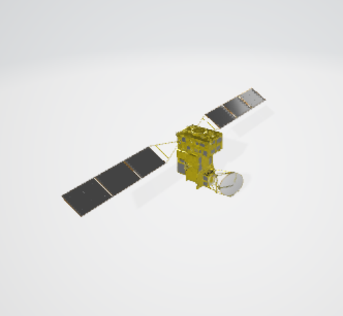
GOSAT-GW viewed from a different angle, clearly displaying the sensor sizes of the mission units AMSR3 and TANSO-3. |
|
|
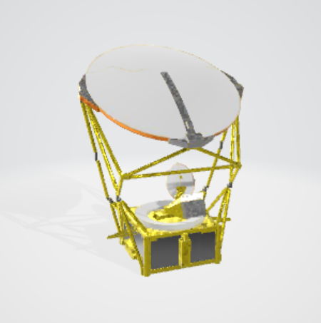
AMSR3 is displayed. Its large round antenna, about 2 meters wide, rotates once every 1.5 seconds. |
AMSR3 Mission
-
Understanding and predicting changes in the water cycle
AMSR3 monitors changes in the global water cycle caused by climate change. The information is used to predict the impact on social life and take measures. - Social implementation in practical fields
- Meteorology
AMSR3 data is regularly used by the Japan Meteorological Agency and other weather agencies worldwide, helping to improve the accuracy of forecasts of typhoons, heavy rain, and other natural disasters. - Fisheries
Related topic:Satellite Application / Agriculture, Forestry and Fisheries
AMSR3 provides sea surface temperature data used in Ebisu-kun, the marine and weather meteorological information service. - Navigation support
AMSR3 provides data on sea ice concentration and sea surface temperature, contributing to compiling information on sea conditions and sea ice related to safe ship operation and selecting optimal routes.
Related topic:Contribution to the Development of Arctic Sea Route” Applications of Satellite Data for Maritime Domain Awareness (MDA)
- Meteorology
TANSO-3 Mission
-
Monitoring whole-atmosphere monthly average concentrations of carbon dioxide
Compared to 1850-1900, the global temperature has increased by 1.1°C between 2011 and 2022. Several future scenarios have been projected for the year 2100, but all of them predict an increase in temperature, with some predicting an increase of 4 to 5°C.
Accurately understanding the current situation and accumulating data will lead to more accurate predictions of the future. - Verification of anthropogenic greenhouse gas emissions by country
Under the Paris Agreement, all countries, both developed and developing, are making efforts to reduce greenhouse gas emissions. In addition, greenhouse gas emissions are reported by each country to the United Nations. Research is being conducted to examine the differences between these values and estimates based on satellite observation data. It is very important to verify the values reported by each country from multiple perspectives. -
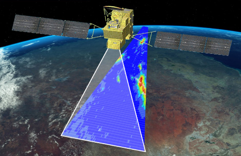
Monitoring large-scale greenhouse gas emission sources
In Focus mode, TANSO-3 will monitor major sources of greenhouse gas emissions, such as urban areas, power plants, and permafrost, by observing around 90 locations once every three days with a swath width of 90 kilometers.
Availability of GOSAT-GW observation data
GOSAT-GW was successfully launched on June 29, 2025.
After separation from the rocket, it will take approximately one year to check and confirm the satellite’s condition before observation data becomes available to the public.
Updates on the satellite’s status will be announced in due course.
Satellite Separation, Deployment, and Observation Process
- Related topics: Calibration/Validation
Technology
-
point
1
Continued global water cycle monitoring for over 20 years with the AMSR series and additional observation channels
-
point
2
Wide-area and highly accurate observation of greenhouse gases by TANSO-3
Continued global water cycle monitoring for over 20 years with the AMSR series and additional observation channels
The Advanced Microwave Scanning Radiometer (AMSR) series has been "observing water on Earth" for over 20 years since 2002. Observations include sea surface temperature, ocean wind speed, soil moisture, snow depth, and sea ice concentration, and this data contributes to a wide range of fields, including weather forecasting, fisheries, maritime navigation support, and understanding of climate change.
<Use cases of the AMSR series>
- Weather forecast
- Improving accuracy in precipitation forecasts
- Enhancing prediction of typhoon and hurricane paths
- Fisheries
- Providing information for deep-sea fisheries by analyzing the relationship between sea surface temperature and fishing grounds
Click here for specific use cases
<Additional AMSR3 functions>
Microwave radiometers measure weak microwaves emitted from the Earth's surface and atmosphere. It is possible to observe physical quantities related to water on the land surface and sea surface, and in clouds by penetrating the clouds. Since it can also observe at night, AMSR3 has the unique ability to perform observations at any time, regardless of weather or time of day.
The Advanced Microwave Scanning Radiometer 3 (AMSR3) on board GOSAT-GW is the successor to the AMSR2 on board GCOM-W “SHIZUKU.” AMSR3 aims to achieve the world's top performance and functionality as a microwave scanning radiometer.
The following functions are added in AMSR3:
- Enhanced observation capabilities with additional channels and improved resolution of existing channels
-
Additional 166 GHz and 183 GHz channels
Because it has been difficult for the AMSR2 to observe snowfall on ground surfaces covered with snow or ice, it was not able to observe snowfall in high-latitude locations such as the Arctic and Antarctic, which are always covered with snow or ice. However, with the addition of 166 GHz and 183 GHz channels, AMSR3 is able to observe the amount of snowfall and precipitation at high latitudes.
This is expected to contribute to improving the accuracy of predictions of sea level rise due to global warming.
-
Additional 166 GHz and 183 GHz channels

-
Additional 183 GHz channel
AMSR3 is able to observe water vapor at high altitudes of 4 to 7 km. By incorporating this data into numerical weather forecasts, the accuracy of forecasts of the scope, path, and intensity of heavy rain and typhoons will be improved.

-
5 km resolution at 166 GHz and 183 GHz channels
166 GHz and 183 GHz channels are designed to measure a resolution of 5 km, allowing for clearer observations than AMSR2. This will enable more detailed understanding of the state of sea ice in the Arctic Ocean and contribute to the planning of Arctic Ocean routes that travel through gaps in the ice.
-
Improved resolution in brightness temperature at 10 GHz channel
While AMSR2 is only possible to observe sea water temperatures beyond 100 km from the coast, AMSR3 is possible to observe areas beyond 20 km from the coast due to the higher resolution of its sea surface temperature product. This will enable it to contribute not only to offshore and deep-sea fishing for Bonito, Tuna, as was previously the case, but also to the exploration of fishing grounds for Sardines, Mackerel, and Horse Mackerel around the continental shelf (beyond approx. 20 km from the coast).
| Satellite | GCOM-W | GOSAT-GW |
| Mission instrument | Advanced Microwave Scanning Radiometer 2 (AMSR2) | Advanced Microwave Scanning Radiometer 3 (AMSR3) |
| Resolution at 10 GHz | 50 km | 30 km |
| Distance from coast where observation is possible |
Beyond 100 km
|
Beyond 20 km
|
<Utilization of AMSR series data>
The AMSR series data can be viewed at the following websites.
The data used was from AMSR-E from June 2002 to October 2011, and from AMSR2 since July 2012. AMSR3 data will also be added in the future.
AMSR Earth Environment Viewer
User Guide
This website visualizes data related to the water cycle, such as precipitation and sea surface temperature.
VISHOP (VIsualization Service of Horizontal scale Observations at Polar region)
This website displays data for the polar regions (Arctic and Antarctic). It allows visualization of sea ice extent as images and graphs.
Wide-area and highly accurate observation of greenhouse gases by TANSO-3
The Total Anthropogenic and Natural emissions mapping SpectrOmeter-3 (TANSO-3) on board GOSAT-GW is the successor to the TANSO-FTS-2 on GOSAT-2 “IBUKI-2”, and observes greenhouse gases over a wide area with high accuracy.
TANSO-3 observes nitrogen dioxide (NO2) in addition to carbon dioxide (CO2) and methane (CH4). Since NO2 is emitted together with CO2 when fossil fuels are burned, simultaneously measuring them is expected to help identify the source of anthropogenic CO2 emissions and improve the accuracy of emission estimates.
| Satellite | GOSAT-2 | GOSAT-GW |
| Mission instrument | Thermal And Near infrared Sensor for carbon Observation - Fourier Transform Spectrometer-2 (TANSO-FTS-2) | Total Anthropogenic and Natural emissions mapping SpectrOmeter-3 (TANSO-3) |
| Observation method | Fourier transform spectroscopy method | Diffraction grating type spectroscopy method |
| Observation mode |
Point-based observation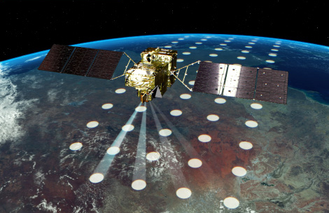

Point-based observation provides results appearing as dots. Some areas may be missing because clouds prevent observations. |
Surface-based observation
Surface-based observation over 911 km swath with 10 km resolution Focus mode Detailed observation over 90 km swath with 3 km resolution 
Surface-based observation provides results like painting the global map. |
| Major observation target |
CO2 CH4 CO |
CO2 CH4 NO2 |
<Utilization of GOSAT series data>
▸ For information on using the data from GOSAT "IBUKI" and GOSAT-2 "IBUKI-2" released by JAXA, please click here.
・GOSAT/GOSAT-2 EORC Monthly Global GHGs Map
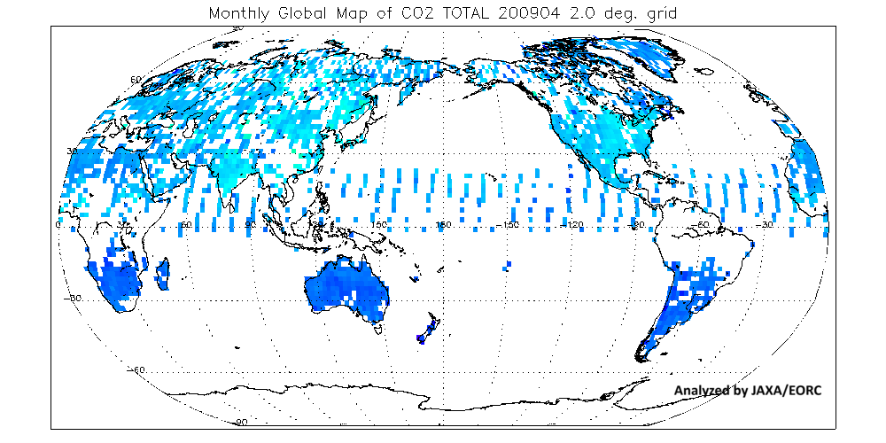
The GOSAT/GOSAT-2 EORC Monthly Global GHGs Map provides visualized data showing monthly CO2 concentrations observed by GOSAT "IBUKI" and GOSAT-2 "IBUKI-2." The map allows users to check seasonal trends, such as increased CO2 absorption in the Northern Hemisphere during summer due to photosynthesis, and the gradual rise of CO2 levels over time. By registering your email address, you can also download observation data with specific numerical values.
▸ GOSAT "IBUKI" and GOSAT-2 "IBUKI-2" data released by the National Institute for Environmental Studies (NIES) are available for viewing and download from the following websites.
▸ For information on using the data from GOSAT and GOSAT-2, please click here.
・GOSAT Data Archive Service (National Institute for Environmental Studies)
・GOSAT-2 Product Archive (National Institute for Environmental Studies)
<Introduction to the GOSAT Series>
▸ GOSAT Series Introduction Video (Produced by the Ministry of the Environment, Japan)
・An introduction to Earth observations using the Greenhouse gases Observing SATellite (GOSAT) series (Ministry of the Environment, Japan)
This video introduces the observation achievements of GOSAT and GOSAT-2, and highlights expectations for the GOSAT-GW mission in Japanese.
Specifications
Specifications and Launch Date of GOSAT-GW
| Satellite name | GOSAT-GW (IBUKI GW) | <Reference satellite> | |
| GOSAT-2 (IBUKI-2) | GCOM-W (SHIZUKU) | ||
| Mission instruments |
Advanced Microwave Scanning Radiometer 3 (AMSR3) Total Anthropogenic and Natural emissions mapping SpectrOmeter-3 (TANSO-3) |
Thermal And Near infrared Sensor for carbon Observation - Fourier Transform Spectrometer-2 (TANSO-FTS-2) Thermal And Near infrared Sensor for carbon Observation - Cloud and Aerosol Imager-2 (TANSO-CAI-2) |
Advanced Microwave Scanning Radiometer 2 (AMSR2) |
| Spacecraft launch Mass | Approximately 2.6 t | 1.8 t | Approximately 2 t |
| Power generation (EOL) | Approximately 5,300 W | 5,000 W | 3,880 W or more |
| Designed lifetime | 7 years or more | 5 years | 5 years |
| Orbit type | Synchronous sub-recurrent orbit | Synchronous sub-recurrent orbit | Synchronous sub-recurrent orbit |
| Altitude | 666 km(Same as GOSAT (IBUKI)) | 613 km | 699.6 km |
| Recurrent period | 3 days | 6 days | 16 days |
| Local Sun Time |
Ascending node: 13:30±15 minutes (Same as GCOM-W (SHIZUKU)) |
Descending node: 13:00±15 minutes |
Ascending node: 13:30±15 minutes |
| Launch date | June 29, 2025 | October 29, 2018 | May 18, 2012 |